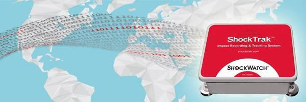
SHOCKTRAK(TM) Brings IOT Visibilty to Shipping
DALLAS – ShockWatch, a leader in logistics monitoring, has released ShockTrak to bring the visibility and immediacy of the Internet of Things (IoT) to companies shipping products around the globe. Knowing when problems occur is the first step toward fixing them. ShockTrak provides location information in four-hour intervals and generates real time alerts when cargo experiences an impact that...
Read More »Teletrac Navman and Garmin Partner to Provide New In-cab Fleet Management Solution in North America
GLENVIEW, Ill. - Teletrac Navman, a leading GPS tracking and fleet management provider, announced a partnership with Garmin to provide a new in-cab tablet solution. This solution enables customers to use Teletrac Navman's fleet management app suite, Drive, with Garmin's world leading navigation. Teletrac Navman Drive on Garmin focuses on daily customer workflows like in-cab communication,...
Read More »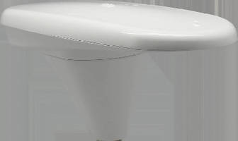
GPS Compass offers better than 2 heading accuracy.
Integrating 2 GPS antennas, multi-axis gyro, and tilt sensor, Vector V104 is based on patented Crescent-® Vector™ technology, which provides code phase management and multipath mitigation. Dual antennas provide heading and position data, while gyro and tilt sensor deliver backup heading information if GPS-based heading is ever lost. Offering- choice of serial or NMEA2000 communications,...
Read More »Satellite Device/GPS Receiver increase satellite operator options.
Combining BCM4551 satellite TV device with BCM4771 GPS receiver, GPS-enabled satellite outdoor unit (ODU) device lets operators track location of subscriber equipment and pinpoint service issues within residence. Satellite solution resides in low-noise block (LNB) ofÃ- subscribers' satellite dishes, enabling operators to better position dish installations and reduce metering equipment...
Read More »
Things to Consider Before Designing Custom Packaging
This e-Book provides pre-design process considerations for custom corrugated packaging.
Read More »GNSS Modules deliver -167 dBm tracking sensitivity.
NEO, MAX, and LEA modules, available for u-blox M8 multi-constellation positioning platform, satisfy diverse requirements by providing scalable range of features: antenna management, integrated filters, data logging, crystal or TXCO, and multiple interfaces. In addition to acquiring and tracking all visible GPS, GLONASS, BeiDou, QZSS, and SBAS satellites, modules can concurrently track any 2 GNSS...
Read More »
Lockheed Martin Completes Major GPS III Flight Software Milestone
NEWTOWN, Pa. - The Lockheed Martin (NYSE: LMT) team developing the U.S. Air Force's next generation Global Position System III satellites has completed a key flight software milestone validating the software's ability to provide reliable and effective command and control for the GPS III satellites planned for launch into orbit. The GPS III program will affordably replace aging GPS satellites,...
Read More »Mobile Device Tracker covers 165 countries.
Global Cell-ID(TM) allows enterprise mobile developers to acquire carrier-certified, permission-based location on their devices in over 165 countries globally. With enhanced location APIs, location-as-a-service (LaaS) platform can deliver mobile device location, even if device has roamed out of the country. LaaS system is designed for global brands and logistics companies such as financial...
Read More »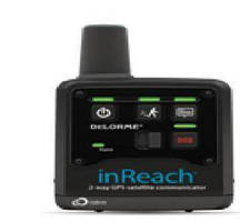
Delorme Inreach(TM) Wins Prestigious Innovation Award for Electronics at Miami International Boat Show
Device is First-to-Market with Affordable Two-Way Global Satellite Messaging YARMOUTH, Maine - DeLorme today announced that its inReach(TM) 2-Way Satellite Communicator has received a coveted National Marine Manufacturers Association (NMMA) Innovation Award for Consumer Electronics. The award was presented at the 2012 Miami International Boat Show, America's premier event of its kind. The...
Read More »Fleet GPS Released for the Construction Industry
Construction companies that consist of a few to hundreds or even thousands of vehicles in constant operation on a daily basis have a responsibility to their fleet to effectively manage and oversee all aspects of driver performance. It is not enough to make sure that all customer appointments have been met at the end of the day. How can a manager possible enforce safer work practices without...
Read More »Fleet GPS for Auto Glass Companies
Auto glass companies most definitely realize the importance of technology. Fleet based businesses that have several to hundreds of vehicles in daily operation need to be able to effectively manage and oversee all aspects of driver performance. The Fleet GPS Program integrated with Smart Risk offers training with interactive courses available 24/7 for the most comprehensible online safety training...
Read More »
Neagle Choice, LLC Announces New Available Services
Neagle Choice has long been known as a quality source for commercial sewing, printing, die cutting, and the manufacturing of a wide range of custom products. Enhancing our service capabilities has been the key to our success, and has driven our growth into many new and exciting markets. Continuing on this trajectory, we now offer precision laser cutting and etching, adding to our long line of manufacturing services. See our video to learn all about it.
Read More »