Rugged, Handheld GPS Receiver is designed for GIS professionals. .
Featuring IPX-7 waterproof casing, eXploristÃ-® Pro 10 GPS receiver has 3 in., WQVGA transflective color touchscreen, 533 MHz processor, and 128 MB RAM, as well as 4 GB online storage expandable to up to 32 GB via microSDHC card slot. Unit delivers 3-5 m accuracy in real time as well as sub-meter or 1-3 m accuracy with a supported Bluetooth-enabled GPS receiver. Its open platform design...
Read More »deCarta MapSearch Hits 1 Million Unique Mobile Users in First 2 Weeks
deCarta provides maps, local search, and directions for Opera Mini users in 14 countries SAN JOSE, Calif. - deCarta's MapSearch mobile application, which provides integrated maps, local search, and directions across a wide variety of handset platforms and countries, has hit the one million user milestone in less than two weeks after its launch on March 22. deCarta MapSearch offers a white label...
Read More »NAVTEQ-® Maps Now Power Panasonic's New Digital Cameras
NAVTEQ location content enables geotagging of photos and images CHICAGO- NAVTEQ, the leading global provider of maps, traffic and location data enabling navigation, location-based services and mobile advertising around the world is supplying NAVTEQÃ-® map and location content for Panasonic's LUMIX DMC-TZ20/ZS10 and DMC-FT3/TS3, the newest member of Panasonic's acclaimed LUMIX Series of...
Read More »Freightliner Trucks to Offer Pre-wire Option for Telogis Telematics Platform
Enterprise platform experts to provide seamless, integrated telematics and routing solutions for Freightliner Business Class M2, 108SD and 114SD vocational trucks. LAS VEGAS, March 28, 2011 - Freightliner Trucks today announced that it will provide its vocational customers with a Telogis telematics pre-wire option. Available in Cummins-equipped Freightliner Business ClassÃ-® M2, 108SD and...
Read More »
Steel Wire Selection Guide for Various Applications
Download this eBook to learn about how steel wire products can be used for a variety of applications.
Read More »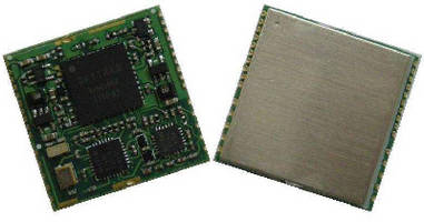
GLONASS/GPS Receiver features 29 sec cold start TTFF.
Measuring 25 x 25 mm, GLONASS/GPS Receiver can be used as drop-in replacement to upgrade existing GPS product. Unit features 145 dBm cold starting and -159 dBm navigation sensitivity. Receiver is capable of operating in 12 tracking channel GPS-only mode, 12 tracking channel GLONASS-only mode, and 24 tracking channel GLONASS + GPS mode. Combining multipath detection and mitigation algorithm,...
Read More »Mobile Vehicle Tracking System utilizes 3-axis accelerometer.
SpiderÃ-® MT 2500 is quad-band GSM/GPRS device with internal antennas, 3-axis accelerometer, analog inputs, and various GPIO. Mobile tracking platform captures and monitors information for fleet and vehicle recovery applications, relaying vehicle and driver behavior information on rapid acceleration, harsh braking, speed violations, and excessive idling. Optional battery is available for...
Read More »Outdoor GPS Receiver has waterproof, rugged design.
Featuring sunlight readable touchscreen, 4-Corners UI, and hard buttons, eXploristÃ-® 610 can be provided with 1:50,000 scale topographic map of Canada or World Edition map that covers 200+ countries. Users can create waypoints, record tracks, and route from point to point; download up to 10,000 paperless geocache GPX files; and review trip stats with 30+ navigational data fields. Integrated...
Read More »Five Inch Navigation Unit meets needs of professional drivers.
Along with bright light visibility, 5550 PRO offers interface that aids interaction when scrolling through searches and configuration settings. Quick-Tabs feature makes critical information readily available to driver, and Junction View with Lane Assist provides 3D images of upcoming highway junctions as well as lane guidance and turn-by-turn directions. Also, map is optimized for miles of road...
Read More »Iridium Provides Satellite Communications for 2011 Iditarod-® Sled Dog Race Safety
Iridium and Service Partners Provide Critical Voice and Data Communications for Racers, Dogs and Volunteers MCLEAN, Va. - Iridium Communications Inc. (Nasdaq:IRDM) is teaming with its service partners, SatCom Global and IonEarth, to provide satellite voice and data services for the Iditarod-® Sled Dog Race, beginning March 5 in Anchorage, Alaska. Iridium is the world's farthest reaching mobile...
Read More »Truck-Specific GPS Units are offered in 5 or 7 in. screen models.
IntelliRouteÃ-® TND(TM) 510, featuring 5 in. screen, and HD IntelliRouteÃ-® TND(TM) 710 with 7 in. screen, both include virtual dashboard with metrics such as odometer, speed, and altitude. Devices help find destinations via latitude and longitude as well as by ZIP code, and they also alert drivers to curves, time zone changes, upcoming construction, border crossing, and speed limit...
Read More »
3Sixty Mission Critical Launches New Service Offering UPS as a Service As A Cost Effective Alternative to UPS Equipment Ownership
At 3Sixty Mission Critical, we specialize in maintaining the performance and uptime of our customer's mission-critical applications. Our services are comprehensive and designed to take on the entire burden of maintenance. Our "UPS as a service" is just another example of how we develop out of the box solutions to help our customers operate more efficiently; see our video to earn more.
Read More »