New Precision Contour Cards Features Custom Color Depth Shading Functionality
Features high detailed 1-foot contours, high-resolution satellite imagery as well as fishing and navigational Points of Interest. C-MAP survey fleet includes shallow-draft boats with surface-drive motors. Makes it easy for anglers to find productive water for key fishing areas.
Read More »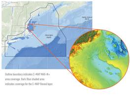
New Reveal East Coast Charts Allows to Reveal The Productive Fishing and Diving Spots
Offers all the navigation data and capability of a C-MAP MAX-N+ card, plus ultra high-resolution bathymetric (HRB) imagery of the sea floor. Detailed charts include C-MAP HRB coastal data, Genesis layer social map data and satellite imagery.
Read More »Navionics Announces Navionics+ and Navionics Updates
Cartography Leader’s Revolutionary New Products Ensure Latest Charts With Freshest Data Wareham, Mass. – Navionics, the leader in electronic charting for the recreational boating market, announced today its new electronic chart standard, Navionics+, and a convenient, reduced cost upgrade for existing charts, Navionics Updates. Providing access to its innovative Freshest Data, Navionics' new...
Read More »Fishfinder/Chartplotter Display is sized for optimal viewing.
Comprising fishfinder,Ã- chartplotter, and combination models, Elite-7 series offers 7 in. widescreen color LED-backlit display. Bundled packages include 83/200 kHz or 50/200 kHz transducer options as well as Navionics Gold cartography. Integrated Hybrid Dual Imaging™ (HDI) combines Broadband Sounder™ and Downscan Imaging™ technologies to provide best view of water column, and...
Read More »
How to Select a Thermal Fluid Heater for Your Process
Do you know the important factors you should consider when comparing different types of thermal fluid heaters?
Read More »Garmin Covers the Waterfront with New Chartplotter Lineup Featuring Pre-Loaded Cartography
OLATHE, Kan., Nov. 14 /-- Garmin International Inc., a unit of Garmin Ltd. (NASDAQ:GRMN), today announced a new line of chartplotter and chartplotter/sonar combination units that feature new, highly-detailed pre-loaded cartography. Garmin's new line of chartplotters literally puts the world at boaters' fingertips, said Gary Kelley, Garmin's vice president of marketing. With Garmin's...
Read More »
Solve Any Large-scale Water Control Problem with the Aqua Dam Flood Barrier
Aqua Dam is the ultimate solution for large-scale water control projects. It combines lightweight, large size, and portability all in one innovative product. To learn more about the uses, and applications of Aqua Dam, or to see it in action, check out our new video to get all the details.
Read More »