New Reveal East Coast Charts Allows to Reveal The Productive Fishing and Diving Spots
Press Release Summary:
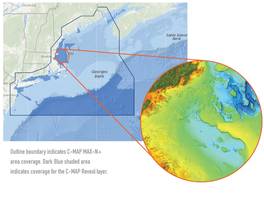
- Offers all the navigation data and capability of a C-MAP MAX-N+ card, plus ultra high-resolution bathymetric (HRB) imagery of the sea floor
- Detailed charts include C-MAP HRB coastal data, Genesis layer social map data and satellite imagery
Original Press Release:
C-MAP Reveal East Coast Charts Now Shipping
West Coast Reveal Charts Scheduled to Start Shipping at the End of July
Tulsa, Okla. – C-MAP®, a leader in digital marine cartography and cloud-based mapping, announced today that C-MAP Reveal charts for the East Coast are now shipping. C-MAP Reveal cartography offers all the navigation data and capability of a C-MAP MAX-N+ card, plus ultra high-resolution bathymetric (HRB) imagery of the sea floor, including the clearest view of structure, wrecks, isolated reefs and ledges in between the contour lines.
The highly detailed C-MAP Reveal imagery replaces shaded-relief data in select areas with more accurate depth variations, allowing it to reveal the best fishing and diving spots. Complete with vector data, these detailed charts include C-MAP HRB coastal data, Genesis layer social map data and satellite imagery that can be overlaid directly on top of the charts. C-MAP Reveal is available for use on Lowrance®, Simrad® or B&G® chartplotters.
“We are pleased to announce the availability of our C-MAP Reveal cartography for the East Coast,” said Knut Frostad, CEO, Navico. “C-MAP Reveal charts feature unrivaled map detail of the sea floor at a much better price than any other cartography.”
New C-MAP Reveal East Coast Charts – Now Shipping
M-NA-Y640-MS - C-MAP REVEAL: US ATLANTIC: GULF OF MAINE - CAPE COD TO LONG ISLAND
M-NA-Y641-MS - C-MAP REVEAL: US ATLANTIC: LONG ISLAND – NORFOLK TO CANYONS
M-NA-Y642-MS - C-MAP REVEAL: US ATLANTIC: NORFOLK TO JACKSONVILLE
New C-MAP Reveal Gulf of Mexico Charts – Now Shipping
M-NA-Y643-MS - C-MAP REVEAL: FLORIDA AND THE BAHAMAS
M-NA-Y644-MS - C-MAP REVEAL: US PT ST. LUCIE TO N. ORLEANS
M-NA-Y645-MS - C-MAP REVEAL: N. ORLEANS TO BROWNSVILLE
New C-MAP Reveal West Coast – Shipping End of July
M-NA-Y652-MS - C-MAP REVEAL: US PACIFIC: SAN DIEGO TO SANTA CRUZ
M- NA-Y653-MS - C-MAP REVEAL: US PACIFIC: POINT SUR TO CAPE BLANCO
M-NA-Y654-MS - C-MAP REVEAL: US PACIFIC: CAPE BLANCO TO CAPE FLATTERY
C-MAP Reveal charts are priced at $299 USD. For more information please visit www.c-map.com.
About C-MAP:
C-MAP offers the world’s largest marine navigation digital chart database, helping its customers explore the digital options and address the complexity of marine operations by providing integrated, intelligent information. C-MAP covers the world with accurate, up-to-date electronic charts, value-added data and services that let you sail safely to distant horizons, fill the boat with fish, or cruise with confidence. Following its recent acquisition by Navico, C-MAP is the fourth brand in Navico’s portfolio, joining Lowrance®, Simrad® and B&G®. For more information, please visit www.c-map.com.
Contact:
Andrew Golden
Rushton Gregory Communications
Tel. 617-413-6521