

Geophysical Survey Systems, Inc.
Salem, NH 03079

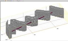
Software integrates GPS data with radar file.
Suited for civil and structural applications, RADAN v6.0 collects and integrates GPS data with corresponding radar file and stores data in Microsoft Access format. Along with 3D viewing and StructureScan Optical Data Processing, software provides user with estimation of maximum depth capability. Incorporated QuickDraw module provides 3D viewing options in one dialog box, while MAP mode allows 2D...
Read More »GSSI Launches New Video Training Series
GSSI, the world’s leading manufacturer of ground penetrating radar (GPR) equipment, launched a new video series as part of their GPR training academy. The video series features short and informative videos focusing on individual product lines to help users through frequently asked questions. The first series is on the StructureScan™ Mini XT – the newest generation of GSSI’s popular...
Read More »GSSI Announces New Technical Applications Specialist
GSSI, the world’s leading manufacturer of ground penetrating radar (GPR) equipment, is pleased to announce the hire of Brett Caldwell to the position of Technical Applications Specialist supporting the geophysical, geotechnical, environmental, and academic markets. Brett is a GPR Technician with a diverse background in geosciences and construction. After serving in the US Army’s 10th Mountain...
Read More »
Software integrates GPS data with radar file.
Suited for civil and structural applications, RADAN v6.0 collects and integrates GPS data with corresponding radar file and stores data in Microsoft Access format. Along with 3D viewing and StructureScan Optical Data Processing, software provides user with estimation of maximum depth capability. Incorporated QuickDraw module provides 3D viewing options in one dialog box, while MAP mode allows 2D...
Read More »