Data and Database Management Software
Software integrates GPS data with radar file.
Press Release Summary:
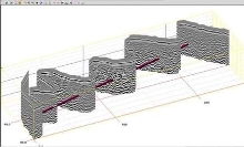
Suited for civil and structural applications, RADAN v6.0 collects and integrates GPS data with corresponding radar file and stores data in Microsoft Access format. Along with 3D viewing and StructureScan Optical Data Processing, software provides user with estimation of maximum depth capability. Incorporated QuickDraw module provides 3D viewing options in one dialog box, while MAP mode allows 2D files collected with GPS data to be viewed in 3D.
Original Press Release:
GSSI Advances State-Of-The-Art RADAN 6.0 Post-Processing Software
Geophysical Survey Systems, Inc. (GSSI), a recognized leader in providing the highest quality, professional grade, ground penetrating radar systems, introduces the advancement of its state-of-the-art RADAN 6.0 post-processing software for civil and structural applications. The software will be able to collect and integrate GPS data with the corresponding radar file while storing the data in convenient MicroSoft Access format.
Along with enhanced and simplified 3D viewing and StructureScan Optical Data Processing, RADAN 6.0 is able to provide the user with an automatic estimation of maximum depth capability. The QuickDraw module provides improved 3D viewing options in a single dialog box while MAP mode allows 2D files collected with GPS data to be viewed in 3D.
The software also offers a familiar Windows-style on-screen context sensitive help option.
"RADAN 6.0 will benefit GSSI system users by offering them the most innovative technology available on the market today," said Chris Hawekotte, Vice President of Sales and Marketing at GSSI. "The easy-to-use software provides each of our GPR systems with unique capabilities."
About GSSI
Geophysical Survey Systems, Inc., located in North Salem, NH, is the world leader in the development and manufacture of Ground Penetrating Radar Systems, referred to as Subsurface Interface Radar (SIR®) Systems. These systems are used to non-destructively explore the subsurface of the ground for a wide variety of industries and to inspect our infrastructure systems. GSSI created the first commercial GPR system and provides the widest range of equipment covering all applications from borehole data collection to high-speed highway and railroad data collection. GSSI sells systems to countries on every continent through a worldwide support network of representatives.
For more information call GSSI at 603-893-1109 or visit www.geophysical.com