Inertial Navigation System supports unmanned applications.
Built on common tactical grade proprietary MEMS inertial sensing core and navigation algorithms, Tactical Series includes VN-110 Inertial Measurement Unit and Attitude Heading Reference System, VN-210 GPS-Aided INS, and VN-310 Dual Antenna GPS/INS. System's 3-axis gyro with
Read More »Holographic Presentation Room delivers true eye contact.
With DVE Immersion Room™,Ã- Microsoft WindowsÃ-® is seen floating in middle of room and people can interact with video objects suspended in mid-air. Other apps, such as PowerPointÃ-® and LyncÃ-®, function in augmented reality mode with 3D objects filling expanse of room with no bulky glasses to wear. Driven by Lync desktop client, real telepresence delivers true eye contact to...
Read More »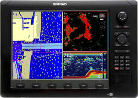
Jeppesen and Navico Announce Compatible Mapping Products
C-MAP by Jeppesen Cartography Available on Lowrance, Simrad Yachting and B&G Chartplotters and Multifunction Displays ENGLEWOOD, Colo. - World navigation expert, Jeppesen, and Navico--the world leader in recreational marine electronics and parent company to the Lowrance, Simrad Yachting and B&G brands--have teamed up to provide consumers with a new charting option. C-MAP MAX-N now provides...
Read More »deCarta MapSearch Hits 1 Million Unique Mobile Users in First 2 Weeks
deCarta provides maps, local search, and directions for Opera Mini users in 14 countries SAN JOSE, Calif. - deCarta's MapSearch mobile application, which provides integrated maps, local search, and directions across a wide variety of handset platforms and countries, has hit the one million user milestone in less than two weeks after its launch on March 22. deCarta MapSearch offers a white label...
Read More »
Top Purchasing Considerations for Cold Storage Units
On-site cold storage is essential in a number of industries. A new walk-in cooler, walk-in freezer or refrigerated trailer is a major investment and having one that fits your specific needs is crucial.
Read More »NAVTEQ-® Maps Now Power Panasonic's New Digital Cameras
NAVTEQ location content enables geotagging of photos and images CHICAGO- NAVTEQ, the leading global provider of maps, traffic and location data enabling navigation, location-based services and mobile advertising around the world is supplying NAVTEQÃ-® map and location content for Panasonic's LUMIX DMC-TZ20/ZS10 and DMC-FT3/TS3, the newest member of Panasonic's acclaimed LUMIX Series of...
Read More »Garmin Delivers Navigation for Ford Commercial Vehicles
OLATHE, Kan., Feb. 6 / / -- Garmin International Inc., a unit of Garmin Ltd. (NASDAQ:GRMN), today announced that its navigation technology will be available in Ford's new 2009 F-150, F-Series Super Duty pickups, and commercial E-Series vans, designed to make business owners more productive and successful. The relationship was announced today at the 2008 Chicago Auto Show. Garmin will provide the...
Read More »NAVTEQ Announces NAVTEQ Traffic in Europe
Leading North American Traffic Provider to Launch Multiple European Products in 2008 CHICAGO and PARIS, Feb. 6 / / -- NAVTEQ (NYSE:NVT), a leading global provider of digital map data for vehicle navigation and location based solutions, today announced the expansion of NAVTEQ Traffic to Europe. The company has announced plans to introduce both its real-time NAVTEQ Traffic product and NAVTEQ...
Read More »INRIX and TomTom Expand North American Partnership to Include Comprehensive Traffic-Enabled Content and Services
Extended agreement features INRIX real-time traffic information, fuel prices, and enhanced incident alerts KIRKLAND, Wash., Jan. 23 - INRIXÃ-®, the leading provider of traffic flow information in the U.S., in partnership with TomTom, the world's largest navigation solutions provider, today announced an agreement to provide INRIX traffic and fuel pricing services for TomTom portable navigation...
Read More »Huaqiang State-of-the-Art Navigation Devices Feature u-blox 5 GPS Modules
THALWIL, Switzerland, January 7 --Huaqiang, a leading GPS and electronics supplier in China, has deployed GPS modules provided by u-blox, the leading Swiss provider of GPS receiver technology, in two state-of-the-art personal navigation devices (PNDs). The cutting edge NAVO N1043 and NAVO N2043 PNDs feature u-blox' recently released LEA-5S high sensitivity GPS module. The module's 50 channels and...
Read More »XM Real-Time NavTraffic Service Now Available in 79 Markets
XM Real-Time NavTraffic Service Now Available in 79 Markets XM NavTraffic Now Covers Most Major and Secondary U.S. Markets WASHINGTON, July 30 / -- XM, the nation's leading provider of satellite radio service, today announced that its real-time satellite information service for GPS navigation will add 29 new markets, providing XM NavTraffic subscribers in the U.S. access to real-time traffic data...
Read More »
Custom Fabrication & Machining Services with Over 30 Years of Experience
As a trusted manufacturer to customers across a broad range of industries, Key Gas Components is a premier provider of CNC machining and tube fabrication. Our entire organization is quality driven and customer-centric, with broad-based manufacturing capabilities that can accommodate the most challenging requirements. See our video to learn more.
Read More »