Software produces 3D urban models with geospecific features.
Share:
Press Release Summary:
FotoG leverages remote sensing and close range photogrammetry to provide geospecific 3D urban authoring capabilities. It merges data collected by satellite or aerial sensors with images captured by handheld digital camera, resulting in geometrically accurate 3D city models that are realistic due to photo texturing. Detailed 3D models can then be manipulated in CAD, GIS, and simulator environments.
Original Press Release:
GeoSpecific 3D Urban Models from Aerial, Satellite, and Hand-Held Digital Camera Images
FotoG Close Range Photogrammetry Adds GeoSpecific Features to 3D Urban Models
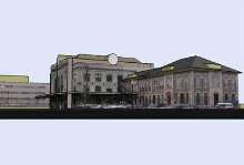
BOULDER, COLORADO-Vexcel Corporation, a world leader in precision urban mapping products and services, is leveraging its remote sensing and close range photogrammetry technologies to provide geospecific 3D urban authoring capabilities - merging data collected by satellite or aerial sensors with images captured by handheld digital camera. The result is 3D city models that are more geometrically accurate and are also exceptionally realistic due to the photo texturing added through Vexcel's award-winning close range photogrammetry software FotoG.
The new mapping capabilities have been added to Vexcel's already broad offerings as a result of work being completed under a Phase I SBIR contract with the US Army Research, Development & Education Command (RDE) Simulation and Training Center in Orlando, Florida. The RDE mission is to ensure US Armed Forces are relevant and ready, and that the products it provides reflect its commitment to US Warfighters. RDE contracted Vexcel to demonstrate the ability to generate geospecific 3D models for use in mission planning and training. Vexcel was selected for its recent advancements in 3D urban modeling and the synergy of those capabilities and its close range photogrammetry expertise.
"The process begins with a geotypical (e.g., building polygon using generic building textures) 3D city model created from satellite or aerial imagery," explained Dr. Jason Szabo, Vexcel's Manager of Close Range Photogrammetry. "Then, using digital photography of local area structures in FotoG, users can add photo textures to building exteriors and interiors, resulting in geometrically accurate and detailed 3D models that can be manipulated in CAD, GIS, and simulator environments."
In addition to military planning, training and simulation uses, applications for detailed, accurate, photo realistic 3D urban models include homeland security, architectural planning, as well as entertainment.
About Vexcel
Founded in 1985, Vexcel Corporation is an internationally recognized remote sensing company with offices in Colorado, Austria and the United Kingdom. Vexcel specializes in Aerial and Close-Range Photogrammetry, Remote Sensing Ground Stations, and Radar (SAR) Technologies.
Jerry Skaw
Marketing Communications Manager
Vexcel Corporation
Innovation in Remote Sensing
tel: (303) 583-0222 o fax: (303) 583-0246
1690 38th Street o Boulder, CO 80301
skaw@vexcel.com
http://www.vexcel.com