Processing System calibrates SAR images.
Share:
Press Release Summary:
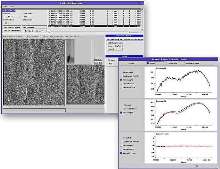
CALPRO(TM) supports PALSAR, Radarsat, and Envisat-ASAR sensors. User-friendly GUI allows operator to import synthetic aperture radar imagery and perform geometric, radiometric, and polarimetric calibrations. Results are saved in corresponding sensor file format for use by SAR image formation processor.
Original Press Release:
Vexcel Announces CALPRO(TM) Radar Image Calibration Processor
BOULDER, COLORADO-Vexcel today announced the release of CALPRO, a new processing system to calibrate synthetic aperture radar (SAR) images. The processor was developed under a June 2003 contract awarded by JGI (Japan) to calibrate images collected by PALSAR, Japan's newest SAR sensor onboard the Advanced Land Observing Satellite (ALOS). CALPRO development was completed in January and the processor was successfully installed this month at the Earth Remote Sensing Data Analysis Center (ERSDAC)-JGI's initial customer for the system.
SAR images that are only relatively calibrated exhibit pixel values that are correct in relation to each other, but do not contain correct physical values when compared to the radar backscatter. The calibration process is necessary to ensure accuracy and adherence of imagery to specifications for standard SAR products.
In addition to the PALSAR sensor, Vexcel's calibration processor supports other SAR sensors, including Radarsat and Envisat-ASAR. CALPRO features a user-friendly GUI that allows the operator to import SAR imagery and then perform geometric, radiometric and polarimetric calibrations. The results are saved in the corresponding sensor file format for use by the SAR image formation processor.
Founded in 1985, Vexcel Corporation is an internationally recognized remote sensing company with affiliated companies in Colorado, Austria and the United Kingdom. The company offers a range of remote sensing products and services to government and commercial markets. Areas of specialization include: i) remote sensing ground systems, ii) SAR research, exploitation software and services, iii) photogrammetry and mapping hardware and software, and iv) GIS products and system solutions.