Data Management System supports digital aerial camera.
Share:
Press Release Summary:
EarthFinder(TM) facilitates cataloging and archiving of aerial images captured by UltraCam-D camera. It includes software hosted on Windows XP server with robotic tape subsystem for data archival, and optional storage devices for data export. Entry, Mid-range, and Enterprise configurations provide respective storage capacities of 8, 52, and 168 TB. Using Web-based GUI, users can search catalog for archived images by geographic location as well as other attributes.
Original Press Release:
Powerful Archive and Catalog System for Managing Digital Aerial Image Data
Vexcel Announces New Version of EarthFinder(TM) Data Management System
BOULDER, COLORADO- Boulder, CO - Vexcel Corporation, a global market leader in remote sensing products and services, today announced added support for the Vexcel UltraCam-D large format digital aerial camera through an updated version of its EarthFinder(TM) data management system. Scheduled for release in February 2004, the product will facilitate the task of cataloging and archiving large quantities of aerial images captured by the UltraCam-D.
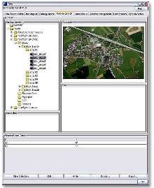
The EarthFinder system is a turnkey data management solution that features Vexcel software hosted on a Windows XP server with a robotic tape subsystem for data archival, and optional storage devices (DVD, CD or tape) for data export purposes. The system allows users to download aerial data directly from the UltraCam Storage and Computing Unit (SCU) or the Vexcel Mobile Storage Unit (MSU)-a lightweight portable storage device for transferring UltraCam data files-via Firewire connections. Once ingested, meta-data is automatically extracted from image headers and quicklook images are generated for each aerial image. This meta information is then cataloged in hierarchical fashion and the actual image data is archived to the robotic storage device. Using the Web-based EarthFinder graphical user interface, users can search the catalog for archived images by geographic location as well as attributes including the project or client name, photogrammetric block, flight line, image scale, flight date, and others.
"For the first time, our customers in the photogrammetry business will be operating with a 100% digital workflow, from aerial data collection to final product deliverables," noted Jolyon Thurgood, Vexcel's Director of Aerial Photogrammetric Products. "The full advantages of the digital photogrammetric workflow can only be realized with a high degree of automation and management at every stage. The EarthFinder system makes simple work of handling the high volume of high-quality digital imagery produced by the UltraCam, and allows the operators to focus on delivering high-value products for their clients."
EarthFinder systems for managing digital aerial data are available in three configurations-entry, mid-range, and "Enterprise"-that will provide respective maximum storage capacities of 8, 52 and 168 terabytes, based on the robotic tape archive configuration. The EarthFinder Enterprise can be upgraded to an almost unlimited capacity and throughput rate, supporting large aerial photo companies operating multiple digital cameras. Entry-level and mid-range systems are designed to support the needs of small and mid-sized aerial photography companies.
Founded in 1985 in Boulder, Colorado, Vexcel Corporation is an internationally recognized remote sensing company that specializes in Aerial and Close-Range Photogrammetry, Radar (SAR) Technologies, and Remote Sensing Ground Stations.