

Softwright LLC
Charlottesville, VA 22906
Share:
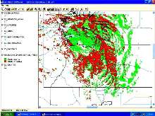
Mapping Software has high-definition mapping engine.
TAP(TM) (Terrain Analysis Package) v5.0, utilizing HD Mapper, generates maps with layers, which can be turned on or off. Layers can be any shapefiles that conform to ESRI international standards. Running on Windows W2K/XP, software includes RF design and coverage presentation tools that allow coverage studies to become one layer plotted on maps. It gives user control over each layer, including...
Read More »RF System Design Software offers increased functionality.
Terrain Analysis Package (TAP) v4.5 includes basic mapping module that allows users to add image files of maps as backgrounds for radio coverage maps. TopoScript(TM) elevation data retrieval engine enables TAP to use various data sources, in addition to 30 sec, 3 sec, and 30 m TAP data. Incorporated RF Facilities Module enables free space calculations. Additional offerings include Antenna Editor...
Read More »