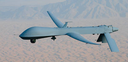
GA-ASIâ™S PREDATOR A RPA TURNS 25
SAN DIEGO – 17 July 2019 – General Atomics Aeronautical Systems, Inc. (GA‑ASI), a leading manufacturer of Remotely Piloted Aircraft (RPA) systems, radars, and electro-optic and related mission systems solutions, marks the 25th anniversary of its Predator A unmanned aircraft this month. Predator A completed its first flight in July 1994 and made its operational debut in 1995. More than...
Read More »
Honda Aircraft Company Celebrates The Delivery of The First Two HondaJet Elites to Hawaii
The HondaJet Elite is the First Light Jet to Enter Service in Hawaii Honolulu, June 28, 2019 /PRNewswire/ -- Honda Aircraft Company celebrated the delivery of the first two HondaJet Elites to Hawaiiduring a special ceremony at Daniel K. Inouye International Airport on Thursday, June 27th. The HondaJet Elite is the first light jet to enter service in Hawaii. Wing Spirit, a newly-established...
Read More »Aerial Imaging System features max payload of 6.0 kg.
Integrating A3 flight controller and Lightbridge 2 video-transmission technology that offers HD live-streaming at distances up to 5 km, Matrice 600 is suited for professional aerial photography, filmmaking, and industrial applications. Six-rotor system features dustproof propulsion system, actively cooled motors, and retractable landing gear for full 360Ã-
Read More »Boeing, BOC Aviation Finalize Order for Two Additional 737-800s
Order grows Singapore-based leasing company's portfolio of fuel-efficient airplanes SEATTLE,Ã- – Boeing [NYSE: BA and BOC Aviation have finalized an order for two additional 737-800s, valued at $186 million at current list prices. The order is a part of the Singapore-based leasing company's effort to grow its portfolio of fuel-efficient airplanes. Building on our order of 80 737 aircraft...
Read More »
Why Use A Locking Cord?
Learn about the benefits of using locking cords in applications that rely on extensive technological infrastructures.
Read More »Northrop Grumman-Built Maritime Surveillance Demonstrator Unmanned Aircraft Surpasses 10,000 Combat Flying Hours
System works as eyes to U.S. Navy fleet commanders in the Middle East SAN DIEGOÃ- – The Northrop Grumman Corporation (NYSE: NOC) built unmanned demonstrator aircraft used for maritime surveillance missions by the U.S. Navy surpassed 10,000 combat flying hours supporting intelligence-gathering missions in the Middle East. The Broad Area Maritime Surveillance Demonstration (BAMS-D) aircraft...
Read More »Predator-Series Aircraft Pivotal to Search and Rescue Missions
Italian MQ-9s to be Upgraded with Lynx Maritime Mode SAN DIEGO – General Atomics Aeronautical Systems, Inc. (GA–ASI), a leading manufacturer of Remotely Piloted Aircraft (RPA), tactical reconnaissance radars, and electro-optic surveillance systems, today announced that MQ-1 PredatorÃ-® and Predator B/MQ-9 Reaper RPA successfully supported local law enforcement officials in their efforts...
Read More »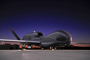
Northrop Grumman's Global Hawk Boasts Best Safety Record Designation
SAN DIEGOÃ- – Northrop Grumman Corporation's (NYSE: NOC) Global Hawk Unmanned Aerial System (UAS) has been designated as the platform with the best safety record in the U.S. Air Force in 2013. Detachment 1 of the 69th Reconnaissance Group contributed to that designation as they maintained exceptional vigilance during all Global Hawk aircraft operations, garnering a perfect safety record and...
Read More »U.S. Air Force Selects the A-29 Super Tucano from Embraer for Its Light Air Support Program
EMBRAER S.A. - NYSE: ERJ; BM&FBOVESPA: EMBR3 SAO PAULO - The U.S. Air Force (USAF) announced today that it has selected the Embraer Defense and Security's A-29 Super Tucano for its Light Air Support (LAS) program. The aircraft will be supplied in partnership with Sierra Nevada Corporation (SNC) as the prime contractor, and will be used to conduct advanced flight training, aerial reconnaissance,...
Read More »Procurement of First Predator XP System Announced
UAE Air Force & Air Defence Signs Contract With IGG IDEX, ABU DHABI – General Atomics Aeronautical Systems, Inc. (GA ASI), a leading manufacturer of Remotely Piloted Aircraft (RPA), tactical reconnaissance radars, and electro-optic surveillance systems, today announced the procurement of its first PredatorÃ-® XP RPA system by the United Arab Emirates (UAE). Predator XP is an updated version...
Read More »Mobotix Secures Multi Million Pound Aerospace Development
London, UK - Mobotix technology is being deployed for a project at Aerohub located in Newquay Cornwall Airport and it will help to secure the new multi-million pound aerospace development area and critical access roads. The South West of England is home to the largest aerospace cluster in Europe with more than 900 aerospace related companies in operation.Ã- Aerospace contributes...
Read More »
Krueger Sentry Gauge Announces the Release of Two New Chemical Sight Gauge Models Designed for Aggressive Liquid Storage Monitoring
Krueger Sentry Gauge, a leader in chemical sight gauges, now offers the ultimate in aggressive liquid storage monitoring devices. From sulfuric and hydrochloric acid to bleach, and acetone, our products are designed with robust features that deliver a long and trouble-free service life. See our video to learn all about this new and innovative line of sight gauges.
Read More »