New Terrain Editing Enables Surveyors to Edit Out Obstructions on Their Site Models
Press Release Summary:
- Worksites can reduce the cumbersome data-cleaning process and avoid inflated volume measurements
- Can use for tighter quotes by removing obstructions for more accurate quantities in their bids
- Let surveyors designate editing access and track terrain changes made by other users
Original Press Release:
Propeller Introduces Terrain Editing Feature in The Propeller Platform
New feature helps surveyors measure sites with greater accuracy, confidence; saves worksites from costly errors made by lack of data
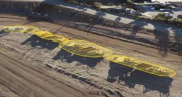
Denver, June 26, 2019 /PRNewswire/ -- Propeller, a cloud-based drone data analytics company, today announced the launch of Terrain Editing, a new feature in the Propeller Platform. Terrain Editing enables surveyors to edit out obstructions or inaccuracies on their site models like a fleet of vehicles, stockpiles, or bridges, ensuring accurate earthwork volume calculations.
Survey data on today's sites can be skewed or incomplete due to obstructions or irregular terrain. Such inaccuracies can take hours to clean up, requiring multiple tools. That inefficiency, along with a general lack of project data, is costing US businesses more than $177B annually. By using Terrain Editing in the Propeller Platform, worksites can reduce the cumbersome data-cleaning process and avoid inflated volume measurements. Beyond improving data on an active worksite, businesses can use Terrain Editing for tighter quotes by removing obstructions for more accurate quantities in their bids.
"Having inaccurate project data is a pain point our customers face every day. Propeller's focus is to arm our customers with the tools to increase accuracy and, ultimately, help them do their jobs more efficiently. While our automated terrain filtering feature removes a majority of unwanted objects from a survey, manual terrain editing is now an option for users who wish to take their surveys a step further," said Rory San Miguel, CEO of Propeller. "This new feature gives surveyors more control over their site data, making sure they can measure surface areas and volumes more accurately."
Terrain Editing in the Propeller Platform also lets surveyors designate editing access and track terrain changes made by other users. With greater control, surveyors can be confident when sharing terrain models with a wider team who can then measure quantities and track earthwork changes themselves using Propeller.
Terrain Editing is now available for all Propeller Platform customers. For more information on the Propeller Platform, please visit https://www.propelleraero.com/propeller-platform/.
About Propeller
Propeller is a global leader in 3D mapping and data analytics solutions that give worksites the power to track, map, and measure their earthwork projects. Headquartered in Sydney, Australia, with a North American office in Denver, Colorado, Propeller's innovative hardware and software products solve real problems for real people. With visual tools everyone can use, Propeller is helping teams on thousands of worksites track, inspect, and report on job progress and productivity safely and accurately. For more information, visit: www.propelleraero.com
Media Contact
Propeller Aero
Source Propeller
Web Site: http://www.propelleraero.com