New HD Chart Card Enables Anglers to Highlight Specific Points of Interest
Press Release Summary:
- Offers custom color depth shading functionality for current fish-holding depths and potential hazard areas information
- Features detailed 1-foot contours, high-resolution satellite imagery, fishing and navigational Points of Interest
- Map display option include four pre-set, depth-shading palettes, such as safety shading
Original Press Release:
C-MAP Releases South Carolina Precision Contour HD Chart Card
1-Foot Contours and Custom Depth Shading Helps Anglers Find Fishing Areas with Ease
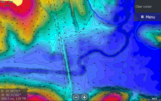
Egersund, Norway – C-MAP®, a leader in digital marine cartography and cloud-based mapping, announced today the release of the latest in its series of digital fishing map cards, Precision Contour HD – South Carolina. After an extensive survey campaign by C-MAP, the new card features highly detailed 1-foot contours, high-resolution satellite imagery and C-MAP’s one-of-a-kind Custom Color Depth Shading*, as well as fishing and navigational Points of Interest. The card is exclusive to chartplotters in the Navico portfolio of brands (Lowrance®, Simrad Yachting and B&G®).
The C-MAP survey fleet includes shallow-draft boats with surface-drive motors, enabling comprehensive coverage of every popular and important fishery in each state covered. Surveyed coverage includes most of the narrowest distant creek arms and shallowest backwaters, as well as key, fish-holding offshore structure like humps and holes, reefs and shoals, ledges and breaklines, sunken islands and points.
Precision Contour HD charts also feature C-MAP’s Custom Color Depth Shading functionality, which enables anglers to highlight specific Points of Interest, including current fish-holding depths and potential hazard areas. Custom Color Depth Shading also enables adjustments to the chart display to reflect high- or low-water conditions that can affect the shapes and edges of shorelines and submerged or partially submerged structures. Additional map display features include four pre-set, depth-shading palettes, such as Safety Shading.
The Precision Contour HD – South Carolina chart card contains the following C-MAP surveyed waterbodies, as well as traditional data on other lakes in South Carolina.
High-definition Precision Contour charts mapped by C-MAP survey crews include:
- Hartwell
- Marion (Santee Cooper)
- Moultrie (Santee Cooper)
- Murray
- J Strom Thurmond (Clarks Hill
- Wateree
- Wylie
Standard definition lakes include:
- Chestnut
- Fishburne Pond 1 and 2
- Payne Branch
- Waterbridge
The C-MAP Precision Contour HD – South Carolina chart card is compatible with most Lowrance, Simrad and B&G chartplotters and is available for $149 USD. Purchase of the card includes a free one-year subscription to C-MAP’s Genesis Edge custom mapping service.
*Custom-Color Depth Shading is compatible with Lowrance HDS Gen 2, HDS Gen 3, Carbon, HDS Live and Elite Ti and Elite Ti2 units. It is not compatible with Lowrance Hook, Lowrance Elite HDI, Elite CHIRP or Elite DSI units.
About C-MAP:
C-MAP® offers the world’s largest marine navigation digital chart database, helping its customers explore the digital options and address the complexity of marine operations by providing integrated, intelligent information. C-MAP covers the world with accurate, up-to-date electronic charts, value-added data and services that let you sail safely to distant horizons, fill the boat with fish, or cruise with confidence. Following its recent acquisition by Navico, C-MAP is the fourth brand in Navico’s portfolio, joining Lowrance®, Simrad Yachting and B&G®. For more information, please visit www.c-map.com.
Contact: Andrew Golden
Rushton Gregory Communications
agolden@rushtongregory.com
Tel. 617-413-6521