New FINDAR Ground Penetrating Radar Features Built-In GPS
Press Release Summary:
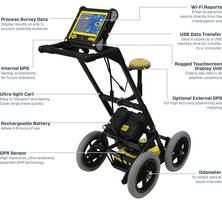
The FINDAR® Ground Penetrating Radar is designed for aiding in search of buried forensic evidences such as clandestine graves, drugs or money buried in metal or plastic containers and buried weapons. The radar generates on-site 3D images in seconds with pinpointing position and depth. The unit’s built-in GPS automatically geo-references grids and screen shots. The unit creates depth slices of large areas by utilizing an accurate GPS and EKKO Project™ software.
Original Press Release:
Introducing FINDAR® - Ground Penetrating Radar for Forensic Investigations
TORONTO, Aug. 8, 2018 /PRNewswire/ - Sensors & Software is pleased to announce an exciting update to FINDAR®, the ground penetrating radar (GPR) created specifically for law enforcement to aid in the search for buried forensic evidence. FINDAR® can locate clandestine graves, drugs or money buried in metal or plastic containers and buried weapons.
Sensors & Software has incorporated customer feedback into this upgraded FINDAR system. The key features are:
Improved Ease of use:
- Minimal system setup enables data collection to start immediately upon arrival at the investigation site.
- The intuitive user interface guides investigators through a systematic grid search, even around obstacles.
- Ultra-light cart for easy transport to and navigation at the investigation site.
- Data and screenshots are saved to a single Project file for easy archiving.
In-field results:
- 3D images are generated on-site in seconds, pinpointing position & depth of potential evidence
- Real-time interpretations can be added and viewed in Map View to identify areas of interest for immediate excavation
- Share findings with the investigation team instantly by emailing screenshots directly from the site
Geo-referenced data:
- Built in GPS automatically geo-references grids & screen shots for future reference and archiving
- Optional external GPS – survey paths, grids and identified targets are displayed in a plan map view
- Automatically exports KMZ file to seamlessly view survey path, screenshot images and interpretations in Google EarthTM.
- Create depth slices of large areas quickly without setting up multiple grids by using an accurate GPS and EKKO_Project™ software
The new FINDAR brings a new level of functionality and efficiency to forensic investigations.
To learn more about FINDAR®, visit FINDAR®
About Sensors & Software Inc.
Founded in 1988, Sensors & Software is the worldwide leader of Ground Penetrating Radar innovations. The company offers a wide range of hardware and software products and services designed to understand what lies beneath the surface and empower informed decision–making.
Learn more about Sensors & Software Inc.:
www.sensoft.ca
CONTACT: Janet Khoshaba, (905) 624-8909, webmaster@sensoft.ca