Latest ScanPlan Handheld Floor Mapper from Faro Captures Floor Plans on Multiple Levels
Press Release Summary:
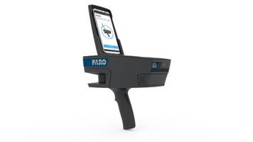
The ScanPlan™ Handheld Floor Mapper assists public safety professionals such as emergency responders, fire and crime scene investigators and security managers. The unit is designed for real time capturing and diagramming of 2D floor plans. It takes measurements, view photos, add pre-drawn symbols for details found in the building and creates finished 2D or 3D diagrams with smart tools. The mapper is suitable for activities such as sporting and cultural events, shopping malls, critical infrastructure and schools and college campuses.
Original Press Release:
FARO® Introduces the ScanPlan™ Handheld Floor Mapper
Enables Fast Mapping of Floor Plans for Public Safety Professionals
LAKE MARY, Fla., Sept. 5, 2018 /PRNewswire/ -- FARO® (NASDAQ: FARO), the world's most trusted source for 3D measurement and imaging solutions for public safety forensics and factory metrology, announces the availability of FARO® ScanPlan™ ( https://tech.faro.com/scanplan/), a solution for fast and easy mapping of floor plans. This next generation 2D handheld mapper is specifically designed to enhance the effectiveness of public safety professionals such as emergency responders, fire and crime scene investigators and security managers. It is ideal for real time capturing and diagramming of 2D floor plans for threat assessment, pre-incident planning and fire protection engineering across a range of places and activities that includes sporting and cultural events, shopping malls, critical infrastructure and schools and college campuses.
A process that used to take hours can now be completed in just minutes.
- Walk through the building/scene at normal speed and simply point the device at walls to capture a 2D floor plan…both in daylight and at night
- Add notes and photographs of critical details to the plan while mapping
- Capture floor plans on multiple levels and organize them into one project
- Take measurements, view photos, add pre-drawn symbols for details found in the building
- Create finished 2D or 3D diagrams quickly with smart tools that that snaps to points for fast drawing or even automatically generate lines from the floor plan
Demonstrations can be scheduled athttps://tech.faro.com/scanplan/.
A Complete Solution
The ScanPlan is a fully integrated solution that includes both the lightweight ScanPlan handheld 2D mapper and FARO Zone 2D diagramming software. This enables end users to configure the captured floor plan into a comprehensive pre-incident diagram. In addition, it delivers actionable, in the moment information as users can seamlessly mount an iOS or Android smartphone of their choice to visualize the floor plan taking shape in real time. This includes the ability to take photos for such items as control panels, sprinklers and hydrants and have them automatically added and geo-located to the correct location.
Easy to Use
The ScanPlan advances the concept of ease of use. Not only can users actually see the floor plan taking shape in real time but operation is as simple as walk, point and capture. As a result, the level of expertise and training required is at a minimum so it can be easily used across the breadth of personnel within an organization.
"As we have stated previously, FARO has a strong strategic focus on the Public Safety community for federal, municipal and private concerns. This is our third new introduction within the last twelve months with solutions specifically designed to optimize productivity for this community and their ability to service their constituents" states Jeff Ruiz, Vice President Public Safety Forensics. "We are encouraged and excited by the enthusiasm in which the community is embracing the ScanPlan solution".
About FARO
FARO is the world's most trusted source for 3D measurement, imaging and realization technology. The Company develops and markets computer-aided measurement and imaging devices and software for the following vertical markets:
- Factory Metrology - High-precision 3D measurement, imaging and comparison of parts and complex structures within production and quality assurance processes
- Construction BIM - 3D capture of as-built construction projects and factories to document complex structures and perform quality control, planning and preservation
- Public Safety Forensics - Capture and analysis of on-site real world data to investigate crash, crime and fire, plan security activities and provide virtual reality training for public safety personnel
- Product Design - Capture detailed and precise 3D data from existing products permitting CAD analysis and redesign, after market design and legacy part replication
- 3D Machine Vision - 3D vision for both control and measurement to the manufacturing floor through 3D sensors and custom solutions
FARO's global headquarters is located in Lake Mary, Florida. The Company also has a technology center and manufacturing facility consisting of approximately 90,400 square feet located in Exton, Pennsylvania containing research and development, manufacturing and service operations of our FARO Laser Tracker and FARO Cobalt Array Imager product lines. The Company's European regional headquarters is located in Stuttgart, Germany and its Asia-Pacific regional headquarters is located in Singapore. FARO has other offices in the United States, Canada, Mexico, Brazil, Germany, the United Kingdom, France, Spain, Italy, Poland, Turkey, the Netherlands, Switzerland, India, China, Malaysia, Thailand, South Korea, Japan, and Australia.
More information is available at http://www.faro.com
CONTACT: Robert Gourdine, Vice President of Global Marketing, E: Robert.Gourdine@faro.com
Web Site: http://www.faro.com