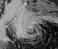
Hurricane Sandy VIIRS Satellite Images
IRVINE, Calif. – FUTEK Advanced Sensor Technology, Inc. was commissioned by NASA to design and develop two cryogenic load cells to operate aboard the satellite producing aerial images of Hurricane Sandy.
NASA's Visible Infrared Imager Radiometer Suite (VIIRS) is one of five instruments currently in use by the National Polar-Orbiting Operational Environment Satellite System (NPOESS) Preparatory Project.
The VIIRS Satellite is responsible for new advances in weather and environmental monitoring, which included producing the aerial images of Hurricane Sandy as it approached the United States' Eastern Coastline.
To ensure that the satellite operates effectively while in orbit, FUTEK developed two cryogenic load cells to monitor the force applied to the cryo-radiator. Special engineering and manufacturing went into the construction of these specific sensors, as they would be operating at extreme temperatures of -300°F.
The VIIRS Satellite presents the future for aerial imagery of atmospheric conditions. With the ability to view highly defined images of clouds, vegetation and sea surfaces, VIIRS has become an effective tool in monitoring potentially detrimental weather circumstances. It is with technology such as this, NASA and meteorologist can continue forewarning communities about approaching hurricanes, tsunamis, and storms.
"FUTEK's very privileged to have worked on this project. It's great to know that technology is progressing in way to provides us with notice on upcoming storms. However, that doesn't discount how strongly these storms can and will affect us. Our hearts go out to all of those affected by Hurricane Sandy," said John Vargas, FUTEK Program Manager.