GIS System suits homeland security applications.
Share:
Press Release Summary:
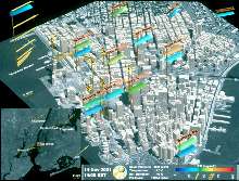
Multi-purpose, web-based VexLink(TM) includes capabilities for emergency preparation and emergency response simulation functions. Emergency preparation tool studies propagation of toxic gas and other airborne contamination for risk assessment and evacuation planning. System combines 3D building and terrain data with formulas that simulate variables such as airflow patterns and wind speed. It also determines unobstructed paths between loudspeakers and surrounding locations.
Original Press Release:
Vexcel Releases Web-Based GIS System for Homeland Security
BOULDER, COLORADO - Vexcel today announced the release of its multi-purpose web-based GIS system, VexLink(TM), for homeland security applications. The system was originally developed to facilitate the installation of high-speed wireless data networks by assessing clear line of sight conditions between geographic locations. The newest expansion of Vexlink's capabilities includes the addition of emergency preparation and emergency response simulation functions.
As an emergency preparation tool, VexLink is used to study the propagation of toxic gas and other airborne contamination. Models created from these studies provide vital information for risk assessment and evacuation planning. The system combines Vexcel's 3D building and terrain data with formulas that simulate variables, such as airflow patterns and wind speed, to show the direction and distance toxic pollutants would likely follow if released. The US Environmental Protection Agency is performing studies of air pollution following the September 11, 2001 World Trade Center collapse using Vexcel's data in this way.
VexLink can also enhance the effectiveness of siren and public address warning systems that are used to alert and direct urban populations during emergency conditions. This application uses Vexcel's urban database to determine unobstructed paths between loudspeakers and surrounding locations. It allows for simulations that identify optimum placement of warning loudspeakers to increase the efficiency of the system. When sound waves are obstructed by buildings and terrain, the range of the warning system is severely limited. In addition, VexLink automatically searches for alternative speaker placements if it determines that a particular path is obstructed.
"VexLink has numerous applications within the Homeland Security categories of risk assessment, public safety, crisis support and security planning," says Wolfgang Walcher, director of Vexcel's mapping and GIS group. "Propagation and warning system studies are just two examples of applications that benefit from utilization of the VexLink system."
Vexcel Corporation, founded in 1985 in Boulder, Colorado, is an internationally recognized remote sensing products and services company that specializes in GIS and mapping services and systems, radar (SAR) technologies, remote sensing ground stations, and aerial and close-range photogrammetry.