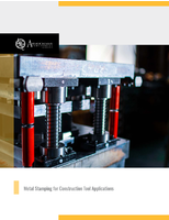
Advanced Navigation

Interface and Logging Unit provides 64 GB capacity.
Controls & Controllers

Interface and Logging Unit provides 64 GB capacity.

Housed in marine-grade aluminum enclosure that is IP68-rated waterproof and dirtproof, Interface and Logging Unit provides data logging, web interface, and time synchronization server. Unit features 6 RS232/RS422 serial ports, 1 CAN bus, 2 Ethernet ports, WiFi, and array of multi-function GPIO pins. All interfaces can operate simultaneously with input and output of data in large selection of...

Read More »
Inertial Navigation System features dual antenna heading.
Test & Measurement

Inertial Navigation System features dual antenna heading.

Operating with 2 GNSS antennas that are mounted fore and aft on vehicle, Spatial FOG Dual continuously measures phase difference of GNSS signal received on each antenna and calculates bearing between antennas, providing high accuracy heading source. This- heading source provides same level of accuracy in both stationary and moving applications and is not affected by magnetic interference....

Read More »
Underwater Acoustic Positioning System operates up to 1,000 m.
Communication Systems & Equipment

Underwater Acoustic Positioning System operates up to 1,000 m.

Housed in palm-sized titanium enclosure, Subsonus USBL combines 8-channel calibrated hydrophone array with integrated inertial navigation system to provide- position, velocity, and heading at depths of up to 1,000 m. Self-calibrating system requires no extra equipment or user intervention for setup, minimizing risk of operator errors. Operating on inverted or standard USBL scheme, Subsonus...

Read More »
Smart Interface Cable determines vehicle speed in real-time.
Test & Measurement

Smart Interface Cable determines vehicle speed in real-time.

Featuring plug-and-play design, OBDII Odometer communicates with- vehicle's on-board computer to determine current vehicle speed and- outputs real-time vehicle speed over RS232 serial data interface. Navigation accuracy down to 0.05% of distance travelled- is achieved when connected to Spatial series GPS/INS products. Smart interface cable has built-in support for 9 OBDII communication...

Read More »
Inertial Navigation System requires single connector.
Chemicals & Gases

Inertial Navigation System requires single connector.

Tightly integrating fiber optic gyroscopes with GNSS and INS, Spatial FOG v2 cuts power consumption and heat generation. GNSS receiver supports L5 GPS signals as well as Chinese BeiDou B1 and B2 satellite signals. Optimized north seeking algorithm allows Spatial FOG to accurately align under conditions that may not have been previously possible. Backwards compatible with version 1.0, v2.0 has...

Read More »
Company News

Dynetics Selects Advanced Navigation for the Gremlins Program

Dynetics has been selected by the Defense Advanced Research Projects Agency (DARPA) to demonstrate the capability to launch unmanned aircraft from warplanes and quickly recover them in mid-air. Named “Gremlins,” these drones are designed to be low cost and reusable within 24 hours after a mission. The unmanned air vehicles utilized in these future operations will carry a variety of different...

Read More »
Interface and Logging Unit provides 64 GB capacity.
Controls & Controllers

Interface and Logging Unit provides 64 GB capacity.

Housed in marine-grade aluminum enclosure that is IP68-rated waterproof and dirtproof, Interface and Logging Unit provides data logging, web interface, and time synchronization server. Unit features 6 RS232/RS422 serial ports, 1 CAN bus, 2 Ethernet ports, WiFi, and array of multi-function GPIO pins. All interfaces can operate simultaneously with input and output of data in large selection of...

Read More »
Inertial Navigation System features dual antenna heading.
Test & Measurement

Inertial Navigation System features dual antenna heading.

Operating with 2 GNSS antennas that are mounted fore and aft on vehicle, Spatial FOG Dual continuously measures phase difference of GNSS signal received on each antenna and calculates bearing between antennas, providing high accuracy heading source. This- heading source provides same level of accuracy in both stationary and moving applications and is not affected by magnetic interference....

Read More »
Underwater Acoustic Positioning System operates up to 1,000 m.
Communication Systems & Equipment

Underwater Acoustic Positioning System operates up to 1,000 m.

Housed in palm-sized titanium enclosure, Subsonus USBL combines 8-channel calibrated hydrophone array with integrated inertial navigation system to provide- position, velocity, and heading at depths of up to 1,000 m. Self-calibrating system requires no extra equipment or user intervention for setup, minimizing risk of operator errors. Operating on inverted or standard USBL scheme, Subsonus...

Read More »
Smart Interface Cable determines vehicle speed in real-time.
Test & Measurement

Smart Interface Cable determines vehicle speed in real-time.

Featuring plug-and-play design, OBDII Odometer communicates with- vehicle's on-board computer to determine current vehicle speed and- outputs real-time vehicle speed over RS232 serial data interface. Navigation accuracy down to 0.05% of distance travelled- is achieved when connected to Spatial series GPS/INS products. Smart interface cable has built-in support for 9 OBDII communication...

Read More »
Inertial Navigation System requires single connector.
Chemicals & Gases

Inertial Navigation System requires single connector.

Tightly integrating fiber optic gyroscopes with GNSS and INS, Spatial FOG v2 cuts power consumption and heat generation. GNSS receiver supports L5 GPS signals as well as Chinese BeiDou B1 and B2 satellite signals. Optimized north seeking algorithm allows Spatial FOG to accurately align under conditions that may not have been previously possible. Backwards compatible with version 1.0, v2.0 has...

Read More »

All Topics