

Vexcel Corporation
Boulder, CO 80301
Share:
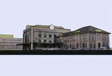
Software produces 3D urban models with geospecific features.
FotoG leverages remote sensing and close range photogrammetry to provide geospecific 3D urban authoring capabilities. It merges data collected by satellite or aerial sensors with images captured by handheld digital camera, resulting in geometrically accurate 3D city models that are realistic due to photo texturing. Detailed 3D models can then be manipulated in CAD, GIS, and simulator environments.
Read More »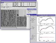
Processing System calibrates SAR images.
CALPRO(TM) supports PALSAR, Radarsat, and Envisat-ASAR sensors. User-friendly GUI allows operator to import synthetic aperture radar imagery and perform geometric, radiometric, and polarimetric calibrations. Results are saved in corresponding sensor file format for use by SAR image formation processor.
Read More »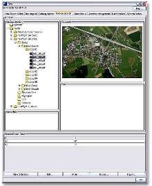
Data Management System supports digital aerial camera.
EarthFinder(TM) facilitates cataloging and archiving of aerial images captured by UltraCam-D camera. It includes software hosted on Windows XP server with robotic tape subsystem for data archival, and optional storage devices for data export. Entry, Mid-range, and Enterprise configurations provide respective storage capacities of 8, 52, and 168 TB. Using Web-based GUI, users can search catalog...
Read More »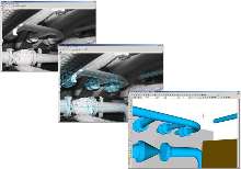
Photogrammetry System creates 3D CATIA models/measurements.
CATIA version of FotoG(TM) allows creation of 3D CAD models and extraction of measurements from film or digital photography and video. CATIA interface to FotoG allows users to develop 3D, as-built CAD models of existing facilities for use in CATIA design environment. Providing capabilities comparable to laser scanning systems, software also offers targeting functionality that automates process of...
Read More »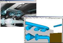
Software creates 3D CAD models from photography.
FotoGÃ-® supports close-range photogrammetry, which allows creation of 3-dimensional models and extraction of precise measurements from film or digital photography. Automatic Target utilizes numerous target patterns that are placed around project area. After capturing photos of area, algorithms identify each target pattern and correlate them across images. Software uses auto-target locations...
Read More »
Data Capture System is Linux based.
Vexcel Data Capture System (VxDCS) incorporates disk array, which may contain up to 10 disk units, into rack mountable chassis. System also houses Vexcel Ion(TM) circuit boards and PC components. Tape drive, for data archiving, is optional. Machine is available in low-end and high-end configurations at respective processing speeds of 200 and 380 Mbps. Product is suited for direct-to-disk data...
Read More »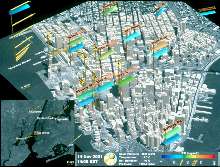
GIS System suits homeland security applications.
Multi-purpose, web-based VexLink(TM) includes capabilities for emergency preparation and emergency response simulation functions. Emergency preparation tool studies propagation of toxic gas and other airborne contamination for risk assessment and evacuation planning. System combines 3D building and terrain data with formulas that simulate variables such as airflow patterns and wind speed. It also...
Read More »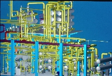
Photogrammetry Software builds realistic models.
FotoG (TM) v5.2 software makes measurements from digital photos and creates CAD models of real world structures and objects. It creates 3D point clouds, which reduce time it takes to create 3D image and makes more accurate representation of complex curves such as hull of ship or curved fender of automobile. It can also create 3D line sketch from digital photos. Other enhancements include improved...
Read More »Vexcel Celebrates 20 Years of Innovation in Remote Sensing
BOULDER, CO, September 23, 2005 -- Vexcel Corporation, internationally renowned for its remote sensing technologies and digital photogrammetric mapping products and services, recently celebrated 20 years of providing innovative products and services to the markets it serves. Founded in 1985, principally by Austrian photogrammetrist Dr. Franz Leberl, Vexcel focused initially on photogrammetric...
Read More »
Software produces 3D urban models with geospecific features.
FotoG leverages remote sensing and close range photogrammetry to provide geospecific 3D urban authoring capabilities. It merges data collected by satellite or aerial sensors with images captured by handheld digital camera, resulting in geometrically accurate 3D city models that are realistic due to photo texturing. Detailed 3D models can then be manipulated in CAD, GIS, and simulator environments.
Read More »
Processing System calibrates SAR images.
CALPRO(TM) supports PALSAR, Radarsat, and Envisat-ASAR sensors. User-friendly GUI allows operator to import synthetic aperture radar imagery and perform geometric, radiometric, and polarimetric calibrations. Results are saved in corresponding sensor file format for use by SAR image formation processor.
Read More »
Data Management System supports digital aerial camera.
EarthFinder(TM) facilitates cataloging and archiving of aerial images captured by UltraCam-D camera. It includes software hosted on Windows XP server with robotic tape subsystem for data archival, and optional storage devices for data export. Entry, Mid-range, and Enterprise configurations provide respective storage capacities of 8, 52, and 168 TB. Using Web-based GUI, users can search catalog...
Read More »
Photogrammetry System creates 3D CATIA models/measurements.
CATIA version of FotoG(TM) allows creation of 3D CAD models and extraction of measurements from film or digital photography and video. CATIA interface to FotoG allows users to develop 3D, as-built CAD models of existing facilities for use in CATIA design environment. Providing capabilities comparable to laser scanning systems, software also offers targeting functionality that automates process of...
Read More »
Software creates 3D CAD models from photography.
FotoGÃ-® supports close-range photogrammetry, which allows creation of 3-dimensional models and extraction of precise measurements from film or digital photography. Automatic Target utilizes numerous target patterns that are placed around project area. After capturing photos of area, algorithms identify each target pattern and correlate them across images. Software uses auto-target locations...
Read More »
Data Capture System is Linux based.
Vexcel Data Capture System (VxDCS) incorporates disk array, which may contain up to 10 disk units, into rack mountable chassis. System also houses Vexcel Ion(TM) circuit boards and PC components. Tape drive, for data archiving, is optional. Machine is available in low-end and high-end configurations at respective processing speeds of 200 and 380 Mbps. Product is suited for direct-to-disk data...
Read More »
GIS System suits homeland security applications.
Multi-purpose, web-based VexLink(TM) includes capabilities for emergency preparation and emergency response simulation functions. Emergency preparation tool studies propagation of toxic gas and other airborne contamination for risk assessment and evacuation planning. System combines 3D building and terrain data with formulas that simulate variables such as airflow patterns and wind speed. It also...
Read More »
Photogrammetry Software builds realistic models.
FotoG (TM) v5.2 software makes measurements from digital photos and creates CAD models of real world structures and objects. It creates 3D point clouds, which reduce time it takes to create 3D image and makes more accurate representation of complex curves such as hull of ship or curved fender of automobile. It can also create 3D line sketch from digital photos. Other enhancements include improved...
Read More »