Navigation Software facilitates boat trip planning.
Press Release Summary:
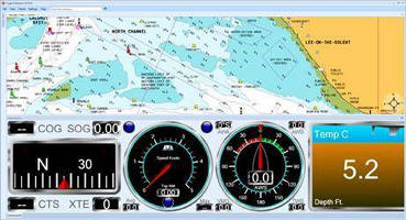
Featuring MarineTouch(TM) touch-screen control optimized for use with Windows 7 and 8 touchscreen tablets, Fugawi Marine 5(TM) provides ClearChart(TM) chart presentation, SurePlanner(TM) route and waypoint planning, and ClearDash instrument display, which integrates with Actisense(TM) NGT-1 NMEA 2000® gateway or standalone instruments via NMEA 0183. Boaters can plot GPS position, program autopilot, display Automatic Identification System vessels, and view important data on instrument displays.
Original Press Release:
Northport Systems Introduces Fugawi Marine 5(TM)
Newly Designed Navigation Software Offers the Most Cutting-Edge Technology for Feature-Packed Trip Planning
Toronto, Canada - Software manufacturer Northport Systems Inc. announced today the next-generation of its pioneering, user-friendly marine navigation software, Fugawi Marine 5(TM). Completely redesigned from-the-ground-up to utilize the newest Windows® technology, Fugawi Marine 5 revolutionizes navigation, waypoint management, and chart downloading. The all-new software features MarineTouch(TM) touch-screen control optimized for use with Windows 7 and 8 touchscreen tablets, ClearChart(TM) ultra fast, smooth and brilliantly clear chart presentation, SurePlanner(TM) simple, intuitive and efficient route and waypoint planning, and ClearDash instrument display for sophisticated and versatile instrumentation that integrates with the Actisense(TM) NGT-1 NMEA 2000® gateway or standalone instruments via NMEA 0183. Fugawi Marine 5 software utilizes the most innovative, cutting-edge technology to complement boaters' navigation and planning preferences both on and off the water.
Fugawi Marine 5 is ideal for boaters who require ultimate flexibility for navigation planning or during on-the-water outings to maximize safety, fuel savings and enjoyment. A fully engineered enhancement to its popular tried-and-true Fugawi Marine ENC navigation software, Fugawi Marine 5 gives navigators the ability to plan trips on a PC at home, in the office or on the go, on a PC, tablet or chartplotter at the boat's helm or below deck. Boaters can plot GPS position, plan routes, program an autopilot, display Automatic Identification System (AIS) vessels, and view important data on elegant and crystal-clear instrument displays.
"Our Fugawi Marine 5 offers boaters a powerful set of navigation features, that are easier to use than even before," said Robin Martel, president, Northport Systems. "The software provides feature-packed, modern and intuitive trip planning that allows individuals to plot routes and navigate where they want and when they want, at any given time for increased freedom and safety during on-the-water navigation."
The Fugawi Marine 5 MarineTouch interface features new intuitive menus and touch screen functionality when used with Window 7 and 8 touch screen systems. Providing bright and crystal-clear chart display, the interface has an all-new simple, uncluttered menu and toolbar system. The smart interface allows users to customize button sizes for touch and arrange panes to suit individual preferences, as well as swipe away data panes and toolbars for full screen map views.
Designed to offer the easiest and most intuitive chart management available, the Fugawi Marine 5 ClearChart presentation provides ultra fast, smooth and responsive panning, zooming, and opening and closing of charts. Users can open multiple charts in a tab or split-screen view for unrivaled on-the-water safety and situational awareness. The software supports Navionics Platinum+, Gold, HotMaps and Fish N' Chip cartography; S-57 (NOAA ENC®), Primar and Chartworld S-63 encrypted S-67 charts, NOAA RNC and Canadian Hydrographic BSB Charts, and BSB/EAP NV Charts*. All NOAA charts download and update automatically. Users can download the Fugawi Marine 5 software to two different PCs and share charts between PCs.
The Fugawi Marine 5 SurePlanner offers simple, fast and efficient waypoint and route planning and management. Equipped with a powerful and easy-to-use data library, users can store and manage virtually unlimited historical data. SurePlanner provides boaters the ability to seamlessly transfer waypoints and routes between Fugawi Marine 5 and leading chartplotters and GPS units in a number of file formats by cable or CF, micro SD, SD and MMC memory cards, quickly and hassle-free. The software is also fully compatible with the Fugawi X-Traverse cloud service. X-Traverse supports GPX files and Google Earth (KMZ files), and allows subscribers to seamlessly purchase and download charts; wirelessly transfer waypoints, routes and track between PCs and mobile devices; upload and share user data and photo waypoints with one-click Facebook integration; retrieve GRIB weather data files; and automatically backup data online.
Fugawi Marine 5's sophisticated ClearDash Instrument Display offers integration of instruments with NMEA 2000 input, using the Actisense NGT-1 NMEA 2000 to PC USB interface or NMEA 0183 input. The instrument display function is capable of providing important navigation, engine, wind or weather data, route navigation, autopilot output and advanced AIS overlay. The software is also compatible with an optional Instrument Suite add-on that can turn Fugawi Marine 5 into an advanced display with up to 20 motor and sail instruments.
Fugawi Marine 5 has a suggested retail price of $299.95 and will be available for purchase at the end of March from leading marine and boating stores throughout North America, Europe and Australasia. Instrument Suite software add-ons are available for $99.95, and an upgrade from any previous Fugawi Marine ENC version to Fugawi Marine 5 is $149.95. Customers who purchased Fugawi Marine ENC Version 4.5 on or after October 1, 2011 will be eligible for a free upgrade to Fugawi Marine 5. For more information on Fugawi Marine 5 please visit marine5.fugawi.com. To learn more about Northport Systems and its entire product line, please contact (416) 920-9300 or visit www.fugawi.com.
About Northport Systems Inc.:
Established in 1995 in Toronto, Canada, Northport Systems Inc. (www.fugawi.com) now supplies desktop and mobile navigation and mapping software products and online services to over 130 countries under the Fugawi brand. Northport enjoys a worldwide reputation as a leader in GPS mapping software and innovative GPS applications for the outdoor recreation, marine, tracking and military markets. Fugawi Software, Fugawi Touratel and Fugawi X-Traverse are properties of Northport Systems.
About Fugawi X-Traverse:
Fugawi X-Traverse (www.x-traverse.com) is designed for marine and outdoor enthusiasts who enjoy flexible charting and planning. The innovative application enables users of PC, Mac and mobile software to download charts and exchange data. X-Traverse provides seamless waypoint transfer between an iPad, iPhone or iPod Touch and a PC or Mac, and allows users to safely save, retrieve and move data without cabling between a desktop and a mobile device. X-Traverse also facilitates the direct download of maps and charts to a variety of desktop and mobile application. A regularly updated list of supported maps and charts, compatible applications and supported handsets can be accessed on the X-Traverse website.