Aerial Cameras are available with 3D capabilities.
Press Release Summary:
With 3D Edge, MIST and A3 Edge cameras gain 3D capabilities as performed by ground-based image processing system working in concert with 3D modeling software. Functionality aids in planning ground missions, calculating line of sight, and measuring openings and dimensions. While color and thermal MIST airborne imaging systems bring commercial-level geospatial data to defense and HLS applications, A3 Edge comprises 2 CCDs that collect imagery with footprint of 78,000 pixels.
Original Press Release:
LAAD 2015: VisionMap Adds 3D Capabilities to Its Aerial Cameras
With 3D Edge, 3D maps of defined areas are quickly created, contributing immensely to mission planning
VisionMap’s lightweight MIST Airborne Imaging System is ideal for light aircraft & UAVs; the A3 Edge with 2 CCDs covers large areas in record time
LAAD 2015, Rio de Janeiro, Brazil, April 14-17, 2015, Israel Pavilion, Hall 4, Stand J-39
VisionMap – a leading provider of digital aerial automatic mapping systems – will introduce new 3D capabilities to its popular aerial cameras, MIST and A3 Edge, at LAAD 2015. The new capability, called 3D Edge, is performed by an image processing system located on the ground, along with 3D modeling software. The images produced by the cameras automatically reach the ground unit, and through a sophisticated algorithm, create three-dimensional models.
According to Marcelo Rubin, VisionMap’s VP Marketing & Sales, "We are pleased to present – for the first time at LAAD 2015 – the unique capabilities of our systems to create three-dimensional models. This capability has immense importance for our customers – significantly improving the planning of various types of ground missions, calculating line of sight, measuring openings such as doors and windows as well as heights of buildings or walls, etc. In addition, the system can be used in the preparation of Safe City Projects when performing an analysis of which areas are covered by cameras and which are not."
He continued, "Our airborne camera systems are unique in their ability to create orthophoto and oblique imagery from a single flight, enabling our customers to select the type of map according to the mission. Our cameras, which have been supplied to dozens of satisfied customers, are among the fastest in the world in capturing large areas. MIST, for example, can photograph all of Sao Paulo in only seven hours!"
MIST Airborne Imaging System
VisionMap’s MIST is the first and only airborne imaging system to bring commercial-level geospatial data to a variety of defense and HLS applications. Combining vast area coverage with extremely high resolution, MIST identifies the smallest objects of interest. Thanks to its compact size (11kg) and autonomous operation, MIST is ideal for use on manned as well as unmanned aircraft, providing safe access to required information. MIST imagery is processed in a fully automatic manner, producing high quality, accurate data for various applications. The MIST system is comprised of two models, color and thermal, delivering the most complete picture of the area.
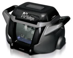
A3 Edge Camera
The A3 Edge Camera, designed for manned aircraft, is comprised of two state-of-the-art CCDs, collecting imagery at record-breaking speed, with a footprint of 78,000 pixels. It provides the highest resolution per altitude, providing sharp, high quality, color imagery.
About VisionMap
VisionMap is a leading provider of digital aerial automatic mapping systems. Leveraging unique multidisciplinary expertise in mapping, photogrammetry, electro-optics and computer vision, VisionMap has created innovative image acquisition and data processing systems. VisionMap’s systems have been successfully deployed and are fully operational.
For more information on VisionMap, please visit: www.visionmap.com
Contact Details:
Haim Baruh
Director of Sales Latin America
haim@visionmap.com
Tel:Â +972-3-6091042