

Leica Geosystems Inc.
Norcross, GA 30092
Share:
Ruggedized GNSS/GIS Handhelds automate dataflow.
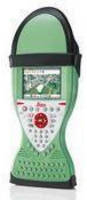
Leica Zeno GIS series integrates EasyIn to promote dataflow between field and office by simultaneously checking in features and GNSS raw data, automatically post-processing GNSS observations, and updating feature vertices to most accurate location. While Leica Zeno 10 provides color graphic display in portrait format and numeric keypad, Leica Zeno 15 offers full QWERTY keyboard and display in...
Read More »Module offers plug-and-play control for CAT machines.
Use of CI-14 CAT Interface Module facilitates installation of Leica Geosystems 2D and 3D machine control systems on CaterpillarÃ-® (CAT) earthmoving equipment. It eliminates effort of installing add-on hydraulic valves in order to control ARO-prepared and non-ARO CAT K/T Series dozers and M Series motorgraders. With no CATÃ-® SEA license activation fee, module is suitable for 2D and 3D...
Read More »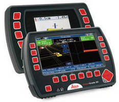
Grading Control System is compatible with multiple machines.
Leica PowerGrade system incorporates PowerSnap docking station, which lets operators move PowerGrade automatic control panels from one machine to another. Machine-specific settings are permanently stored in docking station. Waterproof and designed for harsh environments, system includes color graphic display and 2D to 3D scalability. It provides automatic control of both slope and elevation, with...
Read More »Laser Trackers have maintenance-free internal design.
Utilized for portable applications, Absolute TrackerÃ-® measures 2 ft tall and weighs 48 lb. Model AT901-LR, for aerospace applications, has measurement volume of up to 262 ft when used with corner cube or 98 ft with Leica T-Probe, T-Scan, or T-Mac. Suited for automotive applications, AT901-MR measurement volume is up to 163 feet with corner cube and 59 feet with Leica T-Products, while...
Read More »GPS Surveying System enables one-person operation.
Upgradeable to future satellite positioning systems, GPS900 RTK System includes 72-channel ATX900 GG GLONASS antenna with GNSS technology. It offers choice of controllers, including Leica RS900 with internal memory and Leica RX900c, which features Ã-¼ VGA color display and removable CF card for data transfer. System is suited for foundation and drainage work, alignment stakeout, and instant...
Read More »CAD/CAM Software features intuitive modeling functionality.
Leica CloudWorx v3.3 for AutoCAD allows designers and engineers to visualize and work with 3D point cloud data created by 3D laser scanning systems such as High-Definition Surveying directly within AutoCAD. It features clash detection manager, flange point selection tool that enables precise definition of critical tie-in points, and point density display control capability that helps speed office...
Read More »New Leica fieldPro-Compatible 3D Plant Design Technology Now Available for Rapid Data Capture
Leica Geosystems and COADE announced the release of CADWorx fieldPipe, a jointly developed spatial data capture tool that works within Leica fieldPro, a field-based plug-in to CAD products, to interface with total stations in the field, gathering 3D plant piping geometry information in real-time for use in CADWorx Plant Professional. Norcross, GA, July 3, 2007 -- Leica Geosystems and COADE...
Read More »Laser Tracker Reflectors have break-resistant construction.
Offered as Corner Cube reflector alternative, Break Resistant Reflectors (BRR) work with all models of Leica Laser Tracker in full range up to 40 m. One-piece stainless steel design, with collar around its optic aperture, facilitates handling and provides overall protection. Solution comes in 0.5 and 1.5 in. sizes, with centricity of Ã-
Read More »Leica Geosystems Announces New Software Suite for System 1200 Series
(Norcross, Ga., 05 December 2006) Leica Geosystems today announced the introduction of Leica SmartWorx, a new onboard software for Leica System 1200 instruments. Professionals in surveying and construction are confronted daily by a wide variety of challenges. Leica SmartWorx offers a broad range of functionality to cover all tasks. Not only is SmartWorx powerful, it is also very easy to use....
Read More »Surveying System utilizes GPS and total station technology.
Enabling non-stop, on-the-fly surveying, SmartPole eliminates need to identify control points in office, and then search for control in field. Each TPS set-up can be conducted independently with new coordinates, and orientation can be determined with SmartPole GPS. Once TPS orientation and coordinates are known, all measured points are automatically updated. With SmartPole, both TPS and GPS are...
Read More »
Ruggedized GNSS/GIS Handhelds automate dataflow.
Leica Zeno GIS series integrates EasyIn to promote dataflow between field and office by simultaneously checking in features and GNSS raw data, automatically post-processing GNSS observations, and updating feature vertices to most accurate location. While Leica Zeno 10 provides color graphic display in portrait format and numeric keypad, Leica Zeno 15 offers full QWERTY keyboard and display in...
Read More »Module offers plug-and-play control for CAT machines.
Use of CI-14 CAT Interface Module facilitates installation of Leica Geosystems 2D and 3D machine control systems on CaterpillarÃ-® (CAT) earthmoving equipment. It eliminates effort of installing add-on hydraulic valves in order to control ARO-prepared and non-ARO CAT K/T Series dozers and M Series motorgraders. With no CATÃ-® SEA license activation fee, module is suitable for 2D and 3D...
Read More »
Grading Control System is compatible with multiple machines.
Leica PowerGrade system incorporates PowerSnap docking station, which lets operators move PowerGrade automatic control panels from one machine to another. Machine-specific settings are permanently stored in docking station. Waterproof and designed for harsh environments, system includes color graphic display and 2D to 3D scalability. It provides automatic control of both slope and elevation, with...
Read More »Leica Geosystems to Crown Best Dozer Operator of 2008 During CONEXPO-CON/AGG - Leica PowerGrade Challenge Set to Steal the Show
Job site interactive simulation transforms the showroom floor, putting industry professionals into the driver's seat of the latest technologies reshaping the face of the construction industry. Norcross, Ga. February 22, 2008 -- For the first time, attendees to CONEXPO-CON/AGG, the industry's largest equipment and technology exhibitions, will have an opportunity to participate in the Leica...
Read More »Laser Trackers have maintenance-free internal design.
Utilized for portable applications, Absolute TrackerÃ-® measures 2 ft tall and weighs 48 lb. Model AT901-LR, for aerospace applications, has measurement volume of up to 262 ft when used with corner cube or 98 ft with Leica T-Probe, T-Scan, or T-Mac. Suited for automotive applications, AT901-MR measurement volume is up to 163 feet with corner cube and 59 feet with Leica T-Products, while...
Read More »GPS Surveying System enables one-person operation.
Upgradeable to future satellite positioning systems, GPS900 RTK System includes 72-channel ATX900 GG GLONASS antenna with GNSS technology. It offers choice of controllers, including Leica RS900 with internal memory and Leica RX900c, which features Ã-¼ VGA color display and removable CF card for data transfer. System is suited for foundation and drainage work, alignment stakeout, and instant...
Read More »CAD/CAM Software features intuitive modeling functionality.
Leica CloudWorx v3.3 for AutoCAD allows designers and engineers to visualize and work with 3D point cloud data created by 3D laser scanning systems such as High-Definition Surveying directly within AutoCAD. It features clash detection manager, flange point selection tool that enables precise definition of critical tie-in points, and point density display control capability that helps speed office...
Read More »New Leica fieldPro-Compatible 3D Plant Design Technology Now Available for Rapid Data Capture
Leica Geosystems and COADE announced the release of CADWorx fieldPipe, a jointly developed spatial data capture tool that works within Leica fieldPro, a field-based plug-in to CAD products, to interface with total stations in the field, gathering 3D plant piping geometry information in real-time for use in CADWorx Plant Professional. Norcross, GA, July 3, 2007 -- Leica Geosystems and COADE...
Read More »Laser Tracker Reflectors have break-resistant construction.
Offered as Corner Cube reflector alternative, Break Resistant Reflectors (BRR) work with all models of Leica Laser Tracker in full range up to 40 m. One-piece stainless steel design, with collar around its optic aperture, facilitates handling and provides overall protection. Solution comes in 0.5 and 1.5 in. sizes, with centricity of Ã-
Read More »PDMSWorld.com and Leica Geosystems Join Forces to Better Reach Laser Scan Technology Users Online
(Norcross, Ga., 13 March 2007) PDMSWorld.com and Leica Geosystems, Inc. have joined forces to assist the rapidly growing online community of plant data management system (PDMS) users. The new partnership enables the two companies to work together to raise visibility and increase education regarding laser scan technology to the largest online community of PDMS users. Since the launch of...
Read More »